
Introduction
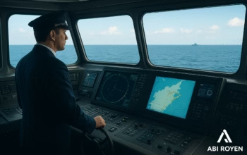
Navigation has always been at the core of maritime operations. From traditional paper charts to sophisticated digital technologies, the shipping industry has continuously evolved to ensure safety and efficiency at sea. One of the most revolutionary technologies in modern navigation is the Electronic Chart Display and Information System (ECDIS).
ECDIS has transformed how ships navigate, providing real-time information, digital charts, and integration with other onboard systems. Today, it is not just a convenience but a mandatory requirement under the International Maritime Organization (IMO) for many classes of vessels.
In this article, we will explore the fundamentals of ECDIS, its functions, components, advantages, and why it has become an essential navigation tool for modern shipping.
What is ECDIS?
Electronic Chart Display and Information System is a computerized navigation system that uses electronic navigational charts (ENCs) to provide ships with accurate, real-time positioning and navigational information.
Unlike traditional paper charts, ECDIS integrates data from various onboard systems such as GPS, radar, AIS (Automatic Identification System), and depth sounders to give mariners a dynamic and interactive map display.
ECDIS is recognized by the IMO as an official alternative to paper charts, provided it meets specific technical and performance standards.
Key Functions of Electronic Chart Display and Information System
The primary purpose of ECDIS is to enhance maritime safety and efficiency. Its core functions include:
- Digital Chart Display
- Displays official ENCs with real-time updates.
- Allows zooming, panning, and layering for detailed navigation.
- Route Planning and Monitoring
- Enables mariners to create, edit, and save voyage routes.
- Monitors ship progress along the planned route and alerts for deviations.
- Integration with Other Navigation Systems
- Interfaces with GPS, radar, AIS, and autopilot for real-time accuracy.
- Provides a comprehensive overview of navigational conditions.
- Automatic Alarms and Warnings
- Alerts the crew of dangers such as shallow waters, restricted zones, or collision risks.
- Improves situational awareness in challenging conditions.
- Data Recording and Playback
- Stores past voyages and navigational data for training or incident investigation.
Main Components of ECDIS
ECDIS is not a standalone tool; it combines hardware and software to deliver its functions. The essential components include:
- Display Unit: High-resolution screen for chart visualization.
- Electronic Navigational Charts (ENCs): Official digital charts approved by hydrographic offices.
- Processor Unit: Computer hardware that runs the ECDIS software.
- Input Devices: Trackball, keyboard, or touchscreen for user interaction.
- Positioning System: GPS or GNSS for accurate location tracking.
- Sensors: Depth sounders, radar, gyrocompass, and AIS for real-time updates.
- Power Supply: Ensures uninterrupted operation during voyages.
Benefits of ECDIS in Maritime Navigation
The adoption of ECDIS provides several advantages over traditional navigation methods:
- Improved Safety
- Reduces the risk of human error by providing alarms and warnings.
- Enhances awareness of navigational hazards.
- Efficiency in Voyage Planning
- Saves time by automating route planning and adjustments.
- Allows optimization of fuel consumption through efficient routing.
- Regulatory Compliance
- Meets IMO requirements for mandatory carriage on certain vessel types.
- Ensures vessels comply with SOLAS (Safety of Life at Sea) standards.
- Cost Savings
- Eliminates the need for costly paper chart updates.
- Reduces crew workload in chart corrections.
- Environmental Benefits
- Supports eco-friendly navigation by minimizing fuel usage and emissions.
Electronic Chart Display and Information System vs Paper Charts
While paper charts have been reliable for centuries, ECDIS offers significant improvements:
- Paper Charts require manual plotting and updates, increasing the risk of mistakes.
- ECDIS automates updates, integrates multiple systems, and provides real-time alarms.
- IMO regulations now recognize ECDIS as a legal substitute for paper charts under specific conditions.
However, mariners are still trained to use paper charts as a backup in case of electronic failures.
Regulations and Standards for ECDIS
The International Maritime Organization (IMO) and the International Hydrographic Organization (IHO) have established strict guidelines for ECDIS use. Some key standards include:
- SOLAS Chapter V: Mandates carriage requirements for ECDIS.
- IHO S-52 & S-57 Standards: Define chart display and ENC data formats.
- Type-Approval: ECDIS equipment must be approved to ensure compliance with performance standards.
These regulations guarantee that ECDIS systems are reliable, standardized, and globally accepted.

Training and Competence in Electronic Chart Display and Information System
The effectiveness of ECDIS depends heavily on the competence of the operators. IMO requires all officers in charge of a navigational watch to undergo ECDIS training, which includes:
- Understanding ENCs and data layers.
- Route planning and execution.
- Handling alarms and warnings.
- Emergency procedures in case of system failure.
Proper training ensures that mariners can maximize the benefits of ECDIS and maintain safe navigation.
Future of ECDIS in Maritime Navigation
With rapid technological advancements, ECDIS continues to evolve. Some trends shaping its future include:
- Integration with Artificial Intelligence (AI) for predictive navigation.
- Cloud-Based Chart Updates for faster and more efficient corrections.
- Augmented Reality (AR) Displays for enhanced situational awareness.
- Cybersecurity Enhancements to protect against digital threats.
As shipping becomes more automated, ECDIS will remain at the heart of smart navigation systems.
Conclusion
The Electronic Chart Display and Information System has revolutionized maritime navigation, replacing paper charts with a safer, faster, and more reliable solution. By integrating digital charts with real-time data from onboard systems, ECDIS improves decision-making, reduces risks, and ensures compliance with international regulations.
For ship operators and mariners, understanding and mastering ECDIS is no longer optional—it is essential. As technology advances, ECDIS will continue to play a vital role in shaping the future of global shipping and maritime safety.